Volcanic Hazard Monitoring and Terrain Analysis at Stromboli with Trinity Pro

The University of Florence (UNIFI) conducted a LiDAR mapping mission over Stromboli volcano in Italy. The mission was flown using our Trinity Pro equipped with the Qube 640 LiDAR payload. The project was led by the University of Florence research team, operating through UNIFI-CPC, a recognised Competence Center supporting the Italian civil protection ecosystem.

The mission aimed to acquire high-precision topographic data to support volcanic hazard assessment, terrain analysis, and simulation modeling in one of Europe’s most active volcanic environments. The resulting datasets contribute to ongoing scientific research and preparedness planning related to volcanic risk and landscape evolution.

Project Specifications

Altitude

140 m AGL

Flight Time

1 hour 30 minutes

Images Takes

1900 +

Drone

Trinity Pro

Camera

Qube 640 LiDAR

Area Surveyed

225 hectares

Wind Speed

2 m/s

Temperature

Warm Mediterranean conditions with active volcanic heat plumes

Challenges

Mapping an active volcanic environment such as Stromboli presents significant operational and scientific challenges:

  • Extreme terrain and steep slopes, making ground surveys and manned flights risky and impractical

  • Dynamic atmospheric conditions, including heat plumes, volcanic gases, and variable winds

  • Limited access and launch locations, due to the island’s geography and protected areas

  • High scientific accuracy requirements, demanding centimeter-level elevation data for deformation analysis and hazard modeling

These constraints require a remote-sensing solution capable of delivering survey-grade data while minimizing risk to personnel and equipment.

Our Solution

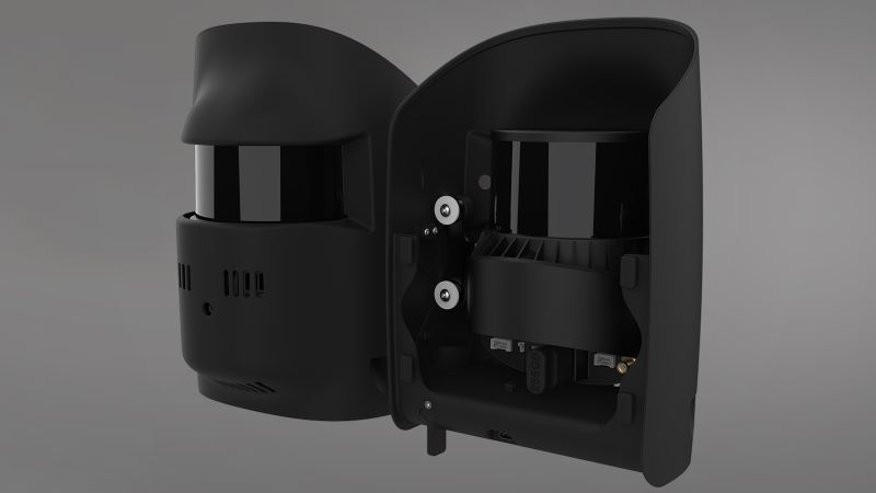
To address these challenges, the University of Florence deployed the Quantum Systems Trinity Pro eVTOL UAV, equipped with the Qube 640 LiDAR payload.

Operating from accessible coastal and hillside locations, the Trinity Pro conducted multiple survey flights covering the Sciara del Fuoco, upper volcanic slopes, and adjacent coastal areas. The platform’s VTOL capability, endurance, and terrain-following performance enabled safe and efficient data acquisition in areas that are otherwise difficult or dangerous to survey.

The mission demonstrated that UAV-based LiDAR mapping with Trinity Pro provides a safe, repeatable, and cost-effective alternative to helicopter or manned-aircraft surveys for volcanic research and monitoring.

The combination of the Trinity Pro and the Qube 640 made it possible to acquire dense, clean, and modelling-ready LiDAR datasets. Despite the complex lithological and geomorphological conditions of the volcanic slope, the Sciara del Fuoco and surrounding areas were captured with high accuracy.
University of Florence (UNIFI)
Designer

Mission Execution

  • Flights conducted as part of a UNIFI field campaign supporting volcanic research and civil-protection preparedness activities

  • Multiple VLOS and extended-range missions flown from secure launch sites

  • Focus areas included volcanic slopes, active flow paths, and coastal zones

  • Trinity Pro operated reliably despite heat plumes, volcanic gases, and variable winds

Collected data were processed by the UNIFI team to generate DTMs, DSMs, and 3D terrain models, supporting ongoing deformation analysis and hazard studies.

Results & Benefits

The mission produced high-density LiDAR point clouds representing the full 3D geometry of Stromboli’s volcanic terrain.

Key outcomes include:

  • Detailed DTMs and DSMs for slope and morphology analysis

  • High-resolution 3D models supporting lava-flow and deformation simulations

  • Reduced need for manned aerial surveys in hazardous airspace

  • Efficient data capture with minimal on-site logistics

The datasets provide long-term value for scientific research, hazard modeling, and preparedness planning.

ROI & Conclusion

The Stromboli project demonstrates the value of UAV-based LiDAR mapping for complex natural environments:

  • Cost efficiency: Reduced reliance on helicopters and manned aircraft

  • Operational safety: Remote data acquisition in hazardous volcanic zones

  • Data quality: Dense, accurate point clouds suitable for advanced modeling

  • Repeatability: Consistent datasets for long-term monitoring and comparison

Conclusion:

The University of Florence’s Stromboli campaign shows how the Trinity Pro combined with the Qube 640 LiDAR enables precise, reliable, and safe data acquisition in one of the world’s most challenging geological settings. The mission reinforces UAV-based LiDAR as a powerful tool for volcanic research and civil-protection preparedness.

MORE USE CASES